


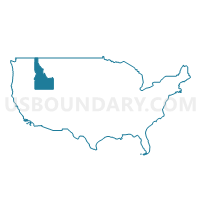
Elmore, Jerome, Blaine, Minidoka, Gooding, Lincoln & Camas Counties PUMA, Idaho
About
Outline

Summary
| Unique Area Identifier | 192780 |
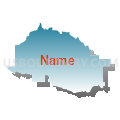
| Name | Elmore, Jerome, Blaine, Minidoka, Gooding, Lincoln & Camas Counties PUMA |
| State | Idaho |
| Area (square miles) | 10,145.09 |
| Land Area (square miles) | 10,077.97 |
| Water Area (square miles) | 67.12 |
| % of Land Area | 99.34 |
| % of Water Area | 0.66 |
| Latitude of the Internal Point | 43.23615340 |
| Longtitude of the Internal Point | -114.59636300 |
Maps

Graphs
Select a template below for downloading or customizing gragh for Elmore, Jerome, Blaine, Minidoka, Gooding, Lincoln & Camas Counties PUMA, Idaho


Neighbors
Neighoring Public Use Microdata Area (by Name) Neighboring Public Use Microdata Area on the Map
- Ada County (South)--Boise (South) & Kuna Cities PUMA, ID
- Bingham (Outside Fort Hall AIR), Madison, Jefferson, Fremont & Teton Counties PUMA, ID
- Canyon (South) & Owyhee Counties--Caldwell & Nampa (South & West) Cities PUMA, ID
- Central Idaho--Lewiston City & Nez Perce Reservation PUMA, ID
- Southeast Idaho--Pocatello, Chubbuck Cities & Fort Hall Reservation PUMA, ID
- Twin Falls & Cassia Counties--Twin Falls City PUMA, ID
Top 10 Neighboring County (by Population) Neighboring County on the Map
- Ada County, ID (392,365)
- Twin Falls County, ID (77,230)
- Bingham County, ID (45,607)
- Elmore County, ID (27,038)
- Cassia County, ID (22,952)
- Jerome County, ID (22,374)
- Blaine County, ID (21,376)
- Minidoka County, ID (20,069)
- Gooding County, ID (15,464)
- Owyhee County, ID (11,526)
Top 10 Neighboring County Subdivision (by Population) Neighboring County Subdivision on the Map
- Twin Falls CCD, Twin Falls County, ID (50,967)
- Mountain Home CCD, Elmore County, ID (24,241)
- Jerome CCD, Jerome County, ID (19,206)
- Orchard CCD, Ada County, ID (19,106)
- Burley CCD, Cassia County, ID (14,177)
- Hailey-Bellevue CCD, Blaine County, ID (13,714)
- Rupert CCD, Minidoka County, ID (9,907)
- Buhl CCD, Twin Falls County, ID (9,612)
- Kimberly CCD, Twin Falls County, ID (7,299)
- Ketchum CCD, Blaine County, ID (6,620)
Top 10 Neighboring Place (by Population) Neighboring Place on the Map
- Mountain Home city, ID (14,206)
- Jerome city, ID (10,890)
- Burley city, ID (10,345)
- Hailey city, ID (7,960)
- Rupert city, ID (5,554)
- Gooding city, ID (3,567)
- Mountain Home AFB CDP, ID (3,238)
- Heyburn city, ID (3,089)
- Wendell city, ID (2,782)
- Ketchum city, ID (2,689)
Top 10 Neighboring Unified School District (by Population) Neighboring Unified School District on the Map
- Boise City Independent School District 1, ID (184,995)
- Twin Falls School District 411, ID (51,059)
- Mountain Home School District 193, ID (24,115)
- Cassia County Joint School District 151, ID (22,454)
- Blaine County School District 61, ID (21,376)
- Minidoka County Joint School District 331, ID (20,877)
- Jerome Joint School District 261, ID (19,389)
- Buhl Joint School District 412, ID (8,666)
- Snake River School District 52, ID (7,898)
- American Falls Joint School District 381, ID (7,200)
Top 10 Neighboring State Legislative District Lower Chamber (by Population) Neighboring State Legislative District Lower Chamber on the Map
- State House District 21, ID (71,377)
- State House District 23, ID (45,710)
- State House District 35, ID (43,409)
- State House District 25, ID (43,165)
- State House District 24, ID (43,046)
- State House District 26, ID (42,443)
- State House District 28, ID (41,905)
- State House District 27, ID (38,757)
- State House District 22, ID (34,066)
Top 10 Neighboring State Legislative District Upper Chamber (by Population) Neighboring State Legislative District Upper Chamber on the Map
- State Senate District 21, ID (71,377)
- State Senate District 23, ID (45,710)
- State Senate District 35, ID (43,409)
- State Senate District 25, ID (43,165)
- State Senate District 24, ID (43,046)
- State Senate District 26, ID (42,443)
- State Senate District 28, ID (41,905)
- State Senate District 27, ID (38,757)
- State Senate District 22, ID (34,066)
Top 10 Neighboring 111th Congressional District (by Population) Neighboring 111th Congressional District on the Map
Top 10 Neighboring Census Tract (by Population) Neighboring Census Tract on the Map
- Census Tract 7, Twin Falls County, ID (10,913)
- Census Tract 9602, Blaine County, ID (9,878)
- Census Tract 9602, Elmore County, ID (8,923)
- Census Tract 9604, Elmore County, ID (8,150)
- Census Tract 9602, Gooding County, ID (7,990)
- Census Tract 9601, Gooding County, ID (7,474)
- Census Tract 105.01, Ada County, ID (7,467)
- Census Tract 13, Twin Falls County, ID (7,299)
- Census Tract 9502, Boise County, ID (7,028)
- Census Tract 9705, Jerome County, ID (6,930)
Top 10 Neighboring 5-Digit ZIP Code Tabulation Area (by Population) Neighboring 5-Digit ZIP Code Tabulation Area on the Map
- 83301, ID (52,010)
- 83647, ID (20,789)
- 83338, ID (19,782)
- 83318, ID (17,226)
- 83716, ID (14,523)
- 83350, ID (12,268)
- 83333, ID (10,472)
- 83316, ID (9,626)
- 83330, ID (6,599)
- 83341, ID (6,491)